
चित्र:Europe, 1700—1714.png

इस पूर्वावलोकन का आकार: ८०० × ५४६ पिक्सेल। दूसरे रेसोल्यूशन्स: ३२० × २१९ पिक्सेल | ६४० × ४३७ पिक्सेल | १,०२४ × ६९९ पिक्सेल | १,२८० × ८७४ पिक्सेल | १,५९० × १,०८६ पिक्सेल।
मूल चित्र (१,५९० × १,०८६ चित्रतत्व, संचिका का आकार: १.०७ MB, माइम प्रकार: image/png)

|
This map of europe image could be re-created using vector graphics as an SVG file. This has several advantages; see Commons:Media for cleanup for more information. If an SVG form of this image is available, please upload it and afterwards replace this template with
{{vector version available|new image name}}.
It is recommended to name the SVG file “Europe, 1700—1714.svg”—then the template Vector version available (or Vva) does not need the new image name parameter. |
सारांश
| विवरण |
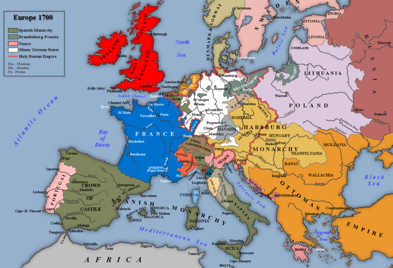
English: Map of Europe 1700. |
| दिनांक | |
| स्रोत |
Own work based on: an image in Trevelyan, George Macaulay (१९३०) England Under Queen Anne, I, लंदन: Longmans, Green and Co.
|
| लेखक | Rebel Redcoat |
| दूसरे संस्करण |
.png)
लाइसेंस
| मैं, इस कार्य का/की कॉपीराइट धारक, इस कार्य को सार्वजनिक डोमेन में प्रकाशित करता/करती हूँ। यह पूरे विश्व में लागू होता है। कुछ देशों में यह कानूनी तौर पर नहीं हो सकता है; ऐसा हो तो: मैं सभी को इस कार्य का इस्तेमाल किसी भी उद्देश्य से, बिना किसी बाधाओं के इन शर्तों के कानून द्वारा अनिवार्य किए तक करने की अनुमति देता/देती हूँ। |
चित्र का इतिहास
चित्र पुराने समय में कैसी दिखती थी यह जानने के लिए दिनांक/समय पर क्लिक करें।
| दिनांक/समय | थंबनेल | आकार | सदस्य | टिप्पणी | |
|---|---|---|---|---|---|
| वर्तमान | १८:०७, ७ नवम्बर २०२२ | | १,५९० × १,०८६ (१.०७ MB) | Gyalu22 | Reverted to version as of 18:08, 26 November 2018 (UTC) |
| १०:०६, १९ जनवरी २०१९ |  | १,५९० × १,०८६ (१.०८ MB) | Julieta39 | Some details according with Stier, H.E. (dir.) ''Grosser Atlas zur Weltgeschichte'', Westermann 1985, {{ISBN|3-14-100919-8}}; ''Putzger historischer Weltatlas'', Cornelsen 1990, {{ISBN|3-464-00176-8}}; Sellier, André & Jean (dir.) « Atlas des Peuples », La Découverte publ.: ''Europe occidentale'', 1995, {{ISBN|2-7071-2505-9}}, ''Europe centrale'', 1992, {{ISBN|2-7071-2032-4}}, ''Orient'', 1993, {{ISBN|2-7071-2222-X}}; ''Atlas istorico-geografic'', Bucharest, Academic publ. {{ISBN|973-27-0500... | |
| १८:०८, २६ नवम्बर २०१८ |  | १,५९० × १,०८६ (१.०७ MB) | Goran tek-en | Changed name on rivers, Southern Bug and Dniester as requested by user:Gikü | |
| १९:१८, ७ जनवरी २०१४ |  | १,५९० × १,०८६ (१,००४ KB) | Rebel Redcoat~commonswiki | Some minor improvements/accuracy | |
| १२:२२, ५ मई २०१२ |  | १,५९० × १,०८६ (१.०७ MB) | Rebel Redcoat~commonswiki | Better version | |
| १२:३९, २२ सितम्बर २०१० |  | १,५९४ × १,०९० (२४५ KB) | Altes | there was not S.-Petersburg in 1700 | |
| १४:५४, २१ जनवरी २०१० |  | १,५९४ × १,०९० (२२४ KB) | Rebel Redcoat~commonswiki | Improvements | |
| १३:५८, २७ मई २००९ |  | १,५९४ × १,०९० (२१० KB) | Rebel Redcoat~commonswiki | Decreased Colour Depth | |
| १३:५६, २७ मई २००९ |  | १,५९४ × १,०९० (६१९ KB) | Rebel Redcoat~commonswiki | Minor Changes | |
| १७:३५, ८ मई २००९ |  | १,५९४ × १,०९० (२१० KB) | Rebel Redcoat~commonswiki | Minor Changes |
चित्र का उपयोग
यह पृष्ठ इस चित्र का इस्तेमाल करता है:
चित्र का वैश्विक उपयोग
इस चित्र का उपयोग इन दूसरे विकियों में किया जाता है:
- arz.wikipedia.org पर उपयोग
- azb.wikipedia.org पर उपयोग
- bo.wikipedia.org पर उपयोग
- ca.wikipedia.org पर उपयोग
- cs.wikipedia.org पर उपयोग
- cv.wikipedia.org पर उपयोग
- da.wikipedia.org पर उपयोग
- el.wikipedia.org पर उपयोग
- en.wikipedia.org पर उपयोग
- en.wikibooks.org पर उपयोग
- eo.wikipedia.org पर उपयोग
- es.wikipedia.org पर उपयोग
- et.wikipedia.org पर उपयोग
- fr.wikipedia.org पर उपयोग
- fr.wikiversity.org पर उपयोग
- hr.wikipedia.org पर उपयोग
- hu.wikipedia.org पर उपयोग
- hy.wikipedia.org पर उपयोग
- ia.wikipedia.org पर उपयोग
- it.wikipedia.org पर उपयोग
- ja.wikipedia.org पर उपयोग
- jv.wikipedia.org पर उपयोग
- mk.wikipedia.org पर उपयोग
- ml.wikipedia.org पर उपयोग
- nl.wikipedia.org पर उपयोग
- nn.wikipedia.org पर उपयोग
- no.wikipedia.org पर उपयोग
- pnb.wikipedia.org पर उपयोग
- pt.wikipedia.org पर उपयोग
- ro.wikipedia.org पर उपयोग
इस चित्र के वैश्विक उपयोग की अधिक जानकारी देखें।