
चित्र:Golden Quadrilateral.svg

पूर्वावलोकन PNG का आकार SVG फ़ाइल: ५३० × ५९९ पिक्सेल दूसरे रेसोल्यूशन्स: २१२ × २४० पिक्सेल | ४२४ × ४८० पिक्सेल | ६७९ × ७६८ पिक्सेल | ९०६ × १,०२४ पिक्सेल | १,८११ × २,०४८ पिक्सेल | ३,२७७ × ३,७०५ पिक्सेल।
मूल चित्र (SVG फ़ाइल, साधारणतः ३,२७७ × ३,७०५ पिक्सेल, फ़ाइल का आकार: ६४३ KB)
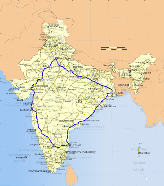
| विवरण | Map of the Golden Quadrilateral in India. |
| दिनांक | (UTC) |
| स्रोत | |
| लेखक |
|
| This is a retouched picture, which means that it has been digitally altered from its original version. The original can be viewed here: India roadway map.svg:
|
मैं, इस कार्य का/की कॉपीराइट धारक, इसे निम्न लाइसेंस के अंतर्गत प्रकाशित करता/करती हूँ:
इस फ़ाइल को क्रिएटिव कॉमन्स श्रेय-समानसांझा 3.0 अनरिपोर्टेड लाइसेंस के अंतर्गत लाइसेंस किया गया है।
- आप खुलकर:
- बाँट सकते हैं – रचना की प्रतिलिपि बना सकते हैं, बाँँट सकते हैं और संचारित कर सकते हैं
- रीमिक्स कर सकते हैं – कार्य को अनुकूलित कर सकते हैं
- निम्नलिखित शर्तों के अंतर्गत:
- श्रेय – यह अनिवार्य है कि आप यथोचित श्रेय प्रदान करें, लाइसेंस की कड़ी प्रदान करें, और अगर कोई बदलाव हुए हों तो उन्हें इंगित करें। आप ऐसा किसी भी उचित तरीके से कर सकते हैं, लेकिन किसी भी तरह उससे यह नहीं संकेत नहीं किया जाना चाहिए कि लाइसेंसधारी द्वारा आपको अथवा आपके इस प्रयोग का समर्थन किया जा रहा हो।
- समानसांझा – अगर आप इस रचना में कोई बदलाव करते हैं या इसपर आधारित कुछ रचित करते हैं तो आप अपने योगदान को सिर्फ इसी या इसके सामान किसी लाइसेंस के अंतर्गत बाँट सकते हैं।
मूल अपलोड लॉग
This image is a derivative work of the following images:
- File:India_roadway_map.svg licensed with Cc-by-sa-3.0
- 2007-04-02T06:14:09Z Gmaxwell 1639x1852 (931168 Bytes) Please do not include copyrighted fonts in your SVGs.
- 2007-04-02T06:13:22Z Gmaxwell 1639x1852 (931168 Bytes) Please do not include copyrighted fonts in your SVGs.
- 2007-01-09T07:33:51Z PlaneMad 1639x1852 (1025350 Bytes) uttaranchal>uttarkhand, minor color corrections and numbering correction
- 2006-11-13T17:04:31Z PlaneMad 1639x1852 (1042154 Bytes) designation for all highways
- 2006-11-09T10:59:17Z PlaneMad 1639x1852 (885509 Bytes) updated karnataka city spellings, added nh 110 112 113 114 116 117 119 121 123 153 154 155 224 225 226 227, corrections in north east states
- 2006-11-06T19:31:09Z PlaneMad 1639x1852 (864712 Bytes) nh designation markers on nhdp highways, rivers enabled, lightened state names, 3d locators for capitals and major cities, minor corrections north east areas
- 2006-10-15T18:01:16Z PlaneMad 1639x1852 (734840 Bytes) Included Nhdp phase IIIA, Changed stroke styles for highways, changed marker locators, added state names, included road legend, added more cities and towns, corrections
- 2006-08-01T18:38:00Z PlaneMad 1639x1852 (619927 Bytes) 100% highway coverage, more towns added, route corrections
- 2006-06-28T18:37:38Z PlaneMad 1639x1852 (1103121 Bytes) added cities and towns throughout india, all rivers added
- 2006-06-27T19:33:15Z PlaneMad 1639x1852 (953120 Bytes) first upload, includes 59000+ km of national highways + NHDP phase I II
Uploaded with derivativeFX
चित्र का इतिहास
चित्र पुराने समय में कैसी दिखती थी यह जानने के लिए दिनांक/समय पर क्लिक करें।
| दिनांक/समय | थंबनेल | आकार | सदस्य | टिप्पणी | |
|---|---|---|---|---|---|
| वर्तमान | ०२:२७, १५ नवम्बर २०१६ | | ३,२७७ × ३,७०५ (६४३ KB) | Offnfopt | doubled height and width to make details easier to see on view of orig SVG, also cleaned up markup |
| ०३:५६, ४ सितम्बर २००९ |  | १,६३९ × १,८५२ (१,०१७ KB) | Abhijitsathe | {{Information |Description=Map of the Golden Quadrilateral in India. |Source=*File:India_roadway_map.svg |Date=2009-09-04 03:54 (UTC) |Author=*File:India_roadway_map.svg: '''PlaneMad''' *derivative work: ~~~ |Permission=see below |other_ve |
चित्र का उपयोग
यह पृष्ठ इस चित्र का इस्तेमाल करता है:
चित्र का वैश्विक उपयोग
इस चित्र का उपयोग इन दूसरे विकियों में किया जाता है:
- bn.wikipedia.org पर उपयोग
- cs.wikipedia.org पर उपयोग
- de.wikipedia.org पर उपयोग
- en.wikipedia.org पर उपयोग
- es.wikipedia.org पर उपयोग
- fa.wikipedia.org पर उपयोग
- fr.wikipedia.org पर उपयोग
- hi.wikipedia.org पर उपयोग
- kn.wikipedia.org पर उपयोग
- ml.wikipedia.org पर उपयोग
- or.wikipedia.org पर उपयोग
- te.wikipedia.org पर उपयोग
- www.wikidata.org पर उपयोग