
चित्र:PanAmericanHwy.png

इस पूर्वावलोकन का आकार: ४३४ × ५९९ पिक्सेल। दूसरे रेसोल्यूशन्स: १७४ × २४० पिक्सेल | ३४८ × ४८० पिक्सेल | ५५६ × ७६८ पिक्सेल | ७४२ × १,०२४ पिक्सेल | १,६०० × २,२०८ पिक्सेल।
मूल चित्र (१,६०० × २,२०८ चित्रतत्व, संचिका का आकार: २.०८ MB, माइम प्रकार: image/png)

|
This road map image could be re-created using vector graphics as an SVG file. This has several advantages; see Commons:Media for cleanup for more information. If an SVG form of this image is available, please upload it and afterwards replace this template with
{{vector version available|new image name}}.
It is recommended to name the SVG file “PanAmericanHwy.svg”—then the template Vector version available (or Vva) does not need the new image name parameter. |
सारांश
| विवरण |
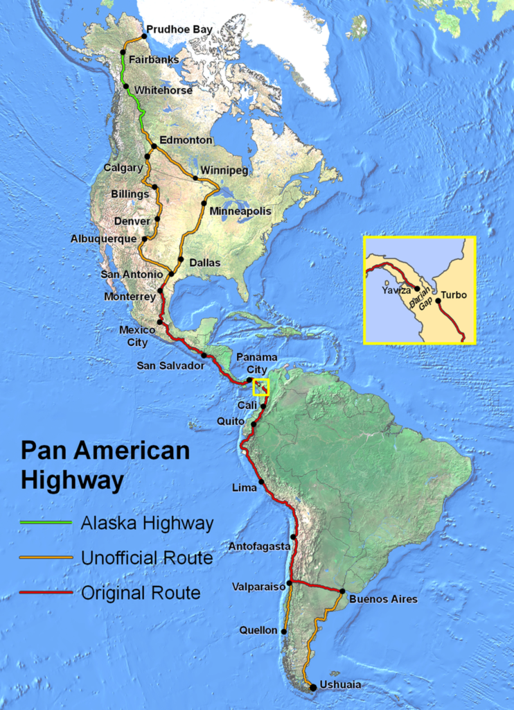
English: Route of the Pan-American Highway. Includes original route and unofficial extensions but doesn't reflect official designation of U.S. interstate highway system. Hotine Oblique Mercator Two Point Natural Origin Projection. |
| स्रोत | अपना कार्य |
| लेखक | Created by en:User:Seaweege and released to PD |
लाइसेंस

|
The copyright holder of this work allows anyone to use it for any purpose including unrestricted redistribution, commercial use, and modification.
Usage notes:
|
चित्र का इतिहास
चित्र पुराने समय में कैसी दिखती थी यह जानने के लिए दिनांक/समय पर क्लिक करें।
| दिनांक/समय | थंबनेल | आकार | सदस्य | टिप्पणी | |
|---|---|---|---|---|---|
| वर्तमान | ०२:३२, १८ जनवरी २०२२ | | १,६०० × २,२०८ (२.०८ MB) | Natewich | Route of the Pan American Highway. Includes original route and unofficial extensions. Hotine Oblique Mercator Two Point Natural Origin Projection. Taken from en:Image:PanAmericanHwy.png. |
| ०१:३३, २७ नवम्बर २००७ |  | १,३२५ × १,८२८ (३.७२ MB) | Jabul | Route of the Pan American Highway. Includes original route and unofficial extensions. Hotine Oblique Mercator Two Point Natural Origin Projection. Taken from en:Image:PanAmericanHwy.png. | |
| ०१:१८, २७ नवम्बर २००७ |  | १,३२५ × १,८२८ (३.७२ MB) | Jabul | ||
| ०२:३६, १७ जून २००७ |  | १,३२५ × १,८२८ (३.६ MB) | SchuminWeb | {{Information |Description=Route of the Pan American Highway. Includes original route and unofficial extensions. Hotine Oblique Mercator Two Point Natural Origin Projection |Source=Originally from [http://en.wikipedia.org en.wikipedia]; description page | |
| १५:२६, २९ दिसम्बर २००६ |  | १,७०० × २,२०० (३.६२ MB) | Chigliak | Original Description: Route of the Pan American Highway. Includes original route and unofficial extensions. Hotine Oblique Mercator Two Point Natural Origin Projection. Taken from en:Image:PanAmericanHwy.png. Created by en:User:Seaweege and rea |
चित्र का उपयोग
यह पृष्ठ इस चित्र का इस्तेमाल करता है:
चित्र का वैश्विक उपयोग
इस चित्र का उपयोग इन दूसरे विकियों में किया जाता है:
- ar.wikipedia.org पर उपयोग
- be-tarask.wikipedia.org पर उपयोग
- be.wikipedia.org पर उपयोग
- bg.wikipedia.org पर उपयोग
- bn.wikipedia.org पर उपयोग
- cs.wikipedia.org पर उपयोग
- de.wikipedia.org पर उपयोग
- de.wikivoyage.org पर उपयोग
- el.wikipedia.org पर उपयोग
- en.wikipedia.org पर उपयोग
- en.wikivoyage.org पर उपयोग
- eo.wikipedia.org पर उपयोग
- et.wikipedia.org पर उपयोग
- eu.wikipedia.org पर उपयोग
- fa.wikipedia.org पर उपयोग
- fi.wikipedia.org पर उपयोग
- fr.wikipedia.org पर उपयोग
- he.wikipedia.org पर उपयोग
- id.wikipedia.org पर उपयोग
- it.wikipedia.org पर उपयोग
- ja.wikipedia.org पर उपयोग
- ka.wikipedia.org पर उपयोग
- km.wikipedia.org पर उपयोग
- ko.wikipedia.org पर उपयोग
- lt.wikipedia.org पर उपयोग
- ml.wikipedia.org पर उपयोग
- mr.wikipedia.org पर उपयोग
- ms.wikipedia.org पर उपयोग
- nl.wikipedia.org पर उपयोग
- no.wikipedia.org पर उपयोग
इस चित्र के वैश्विक उपयोग की अधिक जानकारी देखें।