
चित्र:Worldmaphedo.jpg
इससे बड़ा रेसोल्यूशन उपलब्ध नहीं हैं।
Worldmaphedo.jpg (७०० × ४३७ चित्रतत्व, संचिका का आकार: ५७ KB, माइम प्रकार: image/jpeg)
सारांश
| विवरण |
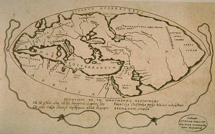
English: World map according to ideas by Posidonius (150-130 B.C.), drawn by 16th century cartographers Petrus Bertius & Melchior Tavernier in 1628. Many of the details in this map couldn't have been known by Posidonius, rather, Bertius and Tavernier show Posidonius' ideas about the positions of the continents. |
|||||||||||||||||||||||||||||||||||||||||||||
| दिनांक | ||||||||||||||||||||||||||||||||||||||||||||||
| स्रोत | Armenica | |||||||||||||||||||||||||||||||||||||||||||||
| लेखक |
|
|||||||||||||||||||||||||||||||||||||||||||||

लाइसेंस
|
This work is in the public domain in its country of origin and other countries and areas where the copyright term is the author's life plus 100 years or fewer. This work is in the public domain in the United States because it was published (or registered with the U.S. Copyright Office) before January 1, 1929. | |
| इस फ़ाइल को कॉपीराइट कानूनों के अंतर्गत सभी संबंधित अधिकारों समेत ज्ञात सीमाओं से मुक्त पहचाना गया है। | |
मूल अपलोड लॉग
Transferred from en.wikipedia to Commons by Woudloper using CommonsHelper.
The original description page was here. All following user names refer to en.wikipedia.
- 2007-02-08 14:26 Artaxiad 700×437×8 (57932 bytes) World map according to Posidonius (150-130 B.C.) {{GFDL-Armenica}}
चित्र का इतिहास
चित्र पुराने समय में कैसी दिखती थी यह जानने के लिए दिनांक/समय पर क्लिक करें।
| दिनांक/समय | थंबनेल | आकार | सदस्य | टिप्पणी | |
|---|---|---|---|---|---|
| वर्तमान | १५:२२, २० मई २००८ | | ७०० × ४३७ (५७ KB) | Woudloper | {{Information |Description={{en|World map according to Posidonius (150-130 B.C.) Source: http://www.armenica.org/cgi-bin/history/en/getHistory.cgi?3=1==Historical%20maps==1=3=AAA}} |Source=Transferred from [http://en.wikipedia.org en.wikipedia]; transfer |
चित्र का उपयोग
यह पृष्ठ इस चित्र का इस्तेमाल करता है:
चित्र का वैश्विक उपयोग
इस चित्र का उपयोग इन दूसरे विकियों में किया जाता है:
- af.wikipedia.org पर उपयोग
- bn.wikipedia.org पर उपयोग
- bs.wikipedia.org पर उपयोग
- ca.wikipedia.org पर उपयोग
- cs.wikipedia.org पर उपयोग
- de.wikipedia.org पर उपयोग
- en.wikipedia.org पर उपयोग
- es.wikipedia.org पर उपयोग
- fa.wikipedia.org पर उपयोग
- fr.wikipedia.org पर उपयोग
- ha.wikipedia.org पर उपयोग
- he.wikipedia.org पर उपयोग
- hr.wikipedia.org पर उपयोग
- hy.wikipedia.org पर उपयोग
- it.wikipedia.org पर उपयोग
- ja.wikipedia.org पर उपयोग
- lv.wikipedia.org पर उपयोग
- nl.wikipedia.org पर उपयोग
- no.wikipedia.org पर उपयोग
- pnb.wikipedia.org पर उपयोग
- sh.wikipedia.org पर उपयोग
- sl.wikipedia.org पर उपयोग
- sr.wikipedia.org पर उपयोग
- th.wikipedia.org पर उपयोग
- uk.wikipedia.org पर उपयोग
- ur.wikipedia.org पर उपयोग
- zh.wikipedia.org पर उपयोग